SLCC GEOSCIENCE DEPARTMENT E-PORTFOLIO ASSIGNMENT:
TRACKING EARTHQUAKES AND VOLCANOES
PART I: Tracking Earthquakes
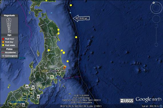
Earthquake #1
Magnitude 5.2,
near the east coast of Honshu, Japan
Date:
Thursday, April 19, 2012 03:33:25 UTC
Thursday, April 19, 2012 12:33:25 PM at epicenter
Depth:
18.00 km (11.18 mi)
Type of tectonic plate boundary: oceanic-oceanic
I believe this earthquake is located on an oceanic-oceanic plate boundary because earthquakes are likely to occur upon oceanic-oceanic plate boundaries. They are also likely to occur in this area known as the Marianas Trench. When two oceanic plates converge one is usually subducted under the other and in the process a deep oceanic trench is formed (i.e. the Marianas Trench).
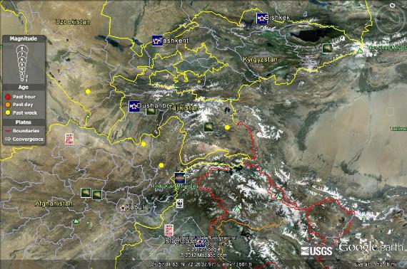
Earthquake #2
Magnitude 4.5,
Tajikistan
Date:
Monday, April 23, 2012 06:27:25 UTC
Monday, April 23, 2012 11:27:25 AM at epicenter
Depth:
129.80 km (80.65 mi)
I believe this earthquake is located on a continental-continental plate boundary because it is located near the Himalayas, which is a poignant example of a continental-continental plate boundary. The collision of India into Asia 50 million years ago caused the Eurasian Plate to crumple up and override the Indian Plate. After the collision, the slow continuous convergence of the two plates over millions of years pushed up the Himalayas and the Tibetan Plateau to their present heights.
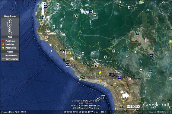
Earthquake #3
Magnitude 5.4,
central Peru
Date:
Saturday, April 21, 2012 11:36:03 UTC
Saturday, April 21, 2012 06:36:03 AM at epicenter
Depth:
90.90 km (56.48 mi)
I believe this earthquake is an example of an oceanic-continental plate boundary because of what I know about the Andes mountain range in South America. When an oceanic plate pushes into and subducts under a continental plate, the overriding continental plate is lifted up and a mountain range is created.
Magnitude 5.6,
south of Tonga
Date:
Tuesday, April 24, 2012 15:15:37 UTC
Wednesday, April 25, 2012 03:15:37 AM at epicenter
Depth:
8.70 km (5.41 mi)
I believe this earthquake is an example of a transform plate boundary because I know this is an area noted for its transform boundaries. Most transform faults are found on the ocean floor. They commonly offset active spreading ridges, producing zig-zag plate margins, and are generally defined by shallow earthquakes. A few, however, occur on land.
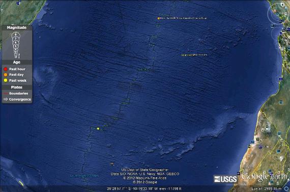
Magnitude 5.1,
southern Mid-Atlantic Ridge
Date:
Saturday, April 21, 2012 01:19:28 UTC
Saturday, April 21, 2012 12:19:28 AM at epicenter
Depth:
10.00 km (6.21 mi)
I believe this earthquake is an example of a divergent plate boundary because the Mid-Atlantic ridge is well-known to be an area of divergent plate boundaries. This earthquake was caused because two plates moved apart from each other, thus causing the disturbance.
PART II: Tracking Volcanoes
Volcano #1
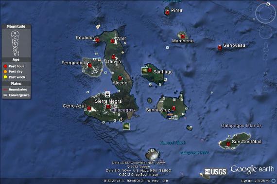
Name: Sierra Negra
Type: Caldera
This type of volcano occurs on a hot spot. The Galapagos Islands are a well known hot spot location.
Volcano #2
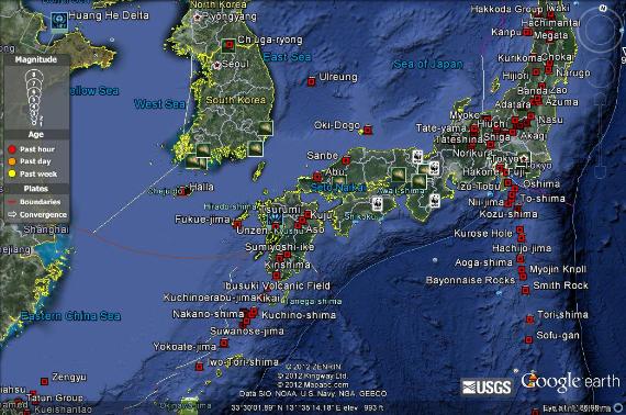
Name: Fukue-jima
Type: Shield Volcano
This type of volcano occurs on a oceanic-oceanic plate boundary.
Volcano #3
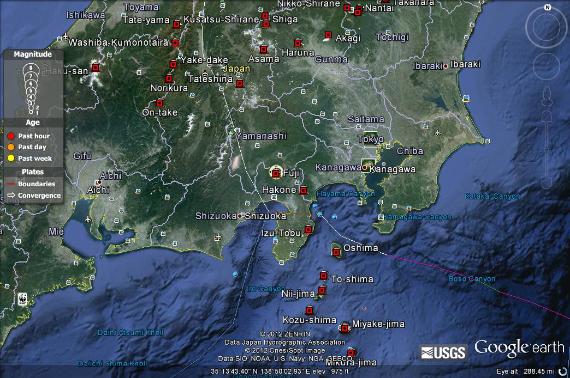
Name: Mt. Fuji
Type: Composite Volcano
This volcano occurs on a oceanic-continental plate boundary, where the oceanic crust has been subducted beneath the continental crust.
Volcano #4
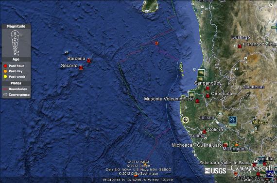
Name: Barcena
Type: Cinder Cone
This volcano is located on a hot spot, where magma has pushed its way through the surface of the crust over time, forming a group of cinder cone volcanoes.
PART III: Reflection
1. Describe the correlation is between earthquakes and volcanoes in terms of the Theory of Plate Tectonics.
According to theory of plate tectonics, Earth is an active planet. The surface of our planet is composed of many individual plates that move and interact, which are constantly changing and reshaping Earth's outer layer. Volcanoes and earthquakes both result from the movement of tectonic plates. The zones along plate boundaries are the most geologically active regions on Earth. Earthquakes are common along all types of boundaries and occur all over the world; volcanoes are generally associated with divergent and convergent boundaries. One of the most well-known plate boundaries encircles the Pacific Ocean, and the frequent earthquakes and volcanic activity along this circle of boundaries have caused it to be called "the Ring of Fire".
2. Analyze the spatial relationship and distribution that exists with these forces of nature.
Earthquakes and volcanoes are strongly related in terms of location and distribution. Just by looking at Google Earth, you can easily see that the locations of earthquakes and the locations of volcanoes are very similar. Both earthquakes and volcanoes occur on tectonic plate boundaries. Both earthquakes and volcanoes occur on tectonic plate boundaries. Earthquakes are caused by a pressure release when the plates move past, move underneath or spread apart from each other. Magma is generated at most plate boundaries. Volcanoes are formed when this magma rises to the surface.
3. Describe what you learned about earthquakes and volcanoes that you did not know before this course.
Well, considering I didn't know much about earthquakes and volcanoes before this course other than thinking they just occurred randomly at random times, I sure have learned a whole lot about what plate tectonics have to do with earthquakes and volcanoes. It was interesting to actually see the spatial relationship and distribution of earthquakes and volcanoes on Google Earth and how they were so similar! Plus it was a pretty sweet excuse to finally play around a bit more in-depth with Google Earth, because how awesome is that anyway??